Google Transit app helps people to know about the public transport facilities available for traveling between two places. This service will be very helpful for the people, who are not familiar with the public transport services like the APSRTC buses and MMTS, in Hyderabad.
Google Transit in Hyderabad
Though Google Transit was already available for few other major cities like Delhi, Mumbai, Ahmedabad, Pune and Bangalore, it was launched in Hyderabad and Chennai on 3rd July.
This service lets the public transport users to access the information on availability of the bus and MMTS services between the places they want to travel in the city. However, you can access the details of only the local bus services in Hyderabad, for now. And the ultimate goal of Google is to expand the services to cover all forms of public transport in all the cities in India.
 How to use Google Transit?
Accessing this service is also quiet easy if you know how to use Google maps. Just visit Google maps and fill the details of your from and to locations in the columns A and B, then click the ‘Get Directions’ button. Now you will be redirected to Google maps where your can see two symbols of a car and a bus, adjacent to each other just above the left sidebar. Click the bus icon which denotes public transport system, then you will be provided with information like the suggested bus routes and the time of journey.
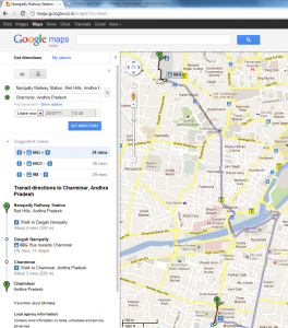
For example, if you want to find the services between Nampally railway station and Charminar in Hyderabad, go to maps.google.co.in and click the ‘Get directions’ link on the left sidebar. Now type Nampally Railway Station in column A and Charminar in column B and click on ‘Get Directions’ button. By default, driving directions are shown. You will need to click on the bus icon above column A to get transit details.
Once you click the bus symbol, you will get all the detailed information like where to take the bus, which bus number to take, number of minutes taken to reach destination, and even when, where and how much time to walk before and after taking the bus.
Below column B, you have a ‘Show options’ link, to you can use other advanced options like at what time you are planning to travel, which mode of transport you would like to use, and what kind of route you would prefer to travel in.
Click here to get step-by-step instructions to use Google Transit.
Google Transit on Mobile phones too
You might be wrong if you think that Google Transit is useful only to people having PC’s and laptops. In a view, to make the service more useful, Google made it available as a mobile application too. So, we can make the best use of it at any time, and any where from our mobile phones. Interestingly, we can also find where exactly the bus stop is located, through GPS.
Accurate information
As told by the officials from Google Maps and Local Product, all the information provided by the Google Transit, regarding available services and the frequency, is quiet certain since it is collected from multiple credible sources. However, the application does not account the real time travel or traffic jams, since it may take much longer time, in case of traffic jams and bus breakdowns.
The transit is also not providing direct instantaneous user feedback or updates on the traffic scenes, that may help other users to avoid traveling in a particular route. On the other hand, users can use the map maker tool to indicate any change in the landmarks indicated on the map.
Now, its our turn to make the most use of this latest app. With the help of Google Transit any one can plan a trip in Hyderabad using the public transport, which makes the vacation more economical.
